360-828-5732
- Home
- Water Leak Detectors
- Locators
- Utility Locators
- Sewerin UT9200 Utility Locators
- RD8200 Underground Utility Locators
- UT930 Pipe Locator
- Rycom Cable Pipe Locators
- CAT4 Pipe Cable Locator
- Utility Marker Locator
- Utility Locator Accessories
- Used Utility Locators
- Locator Sondes
- Locatable Duct Rodders
- Cable Fault Locators
- Ground Penetrating Radar
- Plastic PVC Pipe Locators
- GPS
- Sewer Cameras
- GPS
- Snakes
- Jetters
- Gas Detectors
- Trenchless
- Odor Control
- Pipe Fusion
GPR - Ground Penetrating Radar Equipment
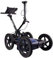
US Radar GPR
- Three frequences with the widest frequency range of any pulsed GPR for both deeper scans and greater details. 163.5 - 1751 Mhz
- Made in USA quality

- 2 year warranty
- 16-inch wheels for scanning in rough terrain
- Lower prices
- Auto soil calibration
- Dual antenna batteries with a combined life of 16 hours per charge and 7 hour tablet battery life
- SmartStack unique algorithm improves image quality and increases depth especially in challenging soils
- Basic and expert modes
- SmartGain2 automatically adjusts the raw signal for optimal noise reduction
- StreetSmart eliminates the need for nearly all post processing
- The handle and tablet mount quickly fold into a compact space for easy transport
- Automatic settings for easy and quick operation
- Expert mode to optimize with fine controls
- Began GPR in 2002.
US Radar GPRover GPR
- Scan and Digitally map within 2-inches, 5 cm without cellular modems or base stations worldwide.
- Tilt correction improves accuracy on slopes, cross slopes and rough terrain
- All the freatures of the Quantum GPR
GPR Ground Penetrating Radar GPRover brochure
Quantum and GPRover GPS Ground Penetrating Radar
- Scan deeper and higher resolution than any other locating technology with three frequencies simultanously.
- View and scan 1,2, or 3 frequencies scans for the deepest penetration and highest detail without compromising with fewer frequencies.
- 250 MMhz, 500 Mhz, 1000 Mhz center frequencies. The widest frequency range in a single pulsed GPR with 163.5 - 1751 Mhz range.
GPR Ground Penetrating Radar Quantum brochure
Q-Series
- Choose the best single frequency for your applications:
- Q25 with 250 Mhz or 270 Mhz center frequencies and penetration depths to 30 feet
- Q5 with 500 Mhz for scans up to 15 feet
- Q10 with 1000 Mhz for scans up to 5 feet
- Low prices
- Premium scanning software included
- Add GPS and GIS software
- Add GPS, GIS, and 3D software
GPR Ground Penetrating Radar Q-Series brochure
100
- Locate targets up to 100 feet depth
- Locate non-metallic pipes, metallic pipes, tanks, voids, bedrock, soil layers, ...
US Radar GPS Tablet Display
- Glare resistant 11.6" daylight readable display
- Resists 4 feet drops
- Withstands water jets, IP65
- Communications: HDMI, WiFI, Bluetooth, USB3.0, Ethernet port
Ground penetrating radar equipment, GPR, ground penetration radar, subsurface radar, georadar, earth sounding radar or GPR explores subsurface utilities without disturbing the earth. The US Radar operates by transmitting one or three electromagnetic signal(s) into the subsurface ground and receives then displays reflections. Varations in subsurface soil conductivity locates objects including plastic pipes, tanks, voids, and more can be detected without digging. Please call or E-mail for ground penetrating demostration, GPR questions, prices.
US Radar Software
Acquisition Software included with all US Radar Models:
- Auto depth calibration for soil conditions
- Unique time varying gain adjusts the gain based on the pulse duration automatically optimizing for deeper targets
- Choose the ideal gain for the clearest images at a specific depth range
- Auto backtrack identifies the target location when the line is aligned with the scanned image
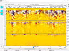
- Position shows the distance and deep to any you touch on the display
- One touch saves a full screen image
- Record the the full scan
- Touch any two points to display the distance, distance between the points and depth
- Label any points with colored symbols and comments for reports and exporting
Advanced Acquistion Sofrware Features
- Calibrate the depth scale using the known depth of targets
- Optimize images wth advanced algorithms low pass filters, high pass filters, peak envelopes, remove DC, ...
- Select the dielectric, attenuation, calculate signal loss
Radar Studio - Post Processing GPR Software
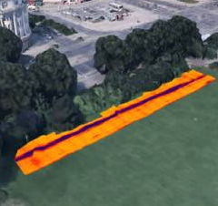
- Create seamless dynamic GPS maps with overlayed subsurface images
- Improve data interpetation using automatic data processing with only basic training needed
- Precisely calibrate velocity and depth with real time 3D images
- Add notes, icons, colors and lines to field knowlede with GPR data
- Export easily to many file formats: seg-Y (.sgy), screenshot image (.png), slice image .(png), survey point list (.csv), Seismic Unix (.su), Video (.avi), Google Earth (kmz), Point Cloud (.asc), Auto Report Points (.rtf), printer ready
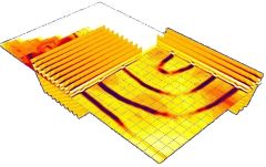
- Create depth slices combine multiple scans showing 3D views from any perspective and connect utilities for the big picture
GPS Integration with GPR
- Connect to most GPS recievers and RTK rovers via USB or Bluetooth
- Tap the screen to display to show position coordinates
- Compatible with GPS, Glonass, and Galileo constallations
- Export GPS points to GIS, CAD or spreadsheets
- Displays and records coordinates with the scans
- Intergrate GPR scans with Google Earth (optional)
- Trigger scans based on GPS location
3D Imaging and Modeling
- Generate milti-scan slice overlays
- Rotate and zoom data slices
- Generate depth slices and peak maps
- Drop paths on to maps with GPS integration
- Time Depth slices of user definable areas
- Adjust transparency and crop image
- Select which scans and slices to display
- Preview generated images prior to adding to 3D models
- Export to Voxler software isosurface display
- Export to laser ccanner / point cloud format
Third Party Software GPR-Slice:

- 2D & 3D time slices
- 3D volume displays
- Vector navigation
- Animation creation
- DXF file creation
- Signal processing
- Image processing
- Split screen comparison
- Topography corrections
- Antenna tilt compensation
- Horizon detection and mapping
- Batch processing
- Customizable multiple image displays
- Easy Grid connection and appending
- Specialized grid filters
- 4D survey processing
- Map transform controls
- Tunnel & cylinder warping
- Graphic exports
- Import, process, and synthesize GPR, magnetometer, resisitivity and EM Data
RJM Equipment Sales Catalog
Related underground utility locator pages:
RD7200 Underground Utility Locators
800-620-4773
360-828-5732
9808 NE 134th Ave
Vancouver, WA 98682
sales@rjmcompany.com